Exploring Nolli Maps: History, Creation, and Significance
Nolli maps, the brainchild of Giambattista Nolli, stand as captivating treasures in the world of cartography. These maps, born in the 18th century, offer a unique perspective on urban landscapes, transcending the traditional role of maps as mere navigational aids.
What sets Nolli maps apart is their holistic representation of cities, going beyond streets and buildings to include public spaces and courtyards. This artistic approach transformed city maps into works of art, capturing the essence of urban life and design during a pivotal period in history.
In the realm of cartography and history, Nolli maps wield immense importance. They provide a rare window into the architectural and urban landscapes of the 18th century. Architects and historians treasure these maps as invaluable resources, allowing them to study architectural styles, building materials, and the evolution of city planning.
Urban planners, too, find Nolli maps indispensable for understanding the changes in urban form over time. Beyond their technical significance, these maps hold cultural importance as symbols of a city's heritage, preserving the memory of historical cityscapes for generations to come.
Join us as we unlock the secrets and stories hidden within these intricate maps, shedding light on the past while offering insights for the future.
Nolli Maps: Unveiling a Cartographic Masterpiece
Nolli maps, often hailed as cartographic masterpieces, were the brainchild of the remarkable Italian surveyor and architect, Giambattista Nolli. Born in 1701, Nolli's legacy transcends mere cartography; his maps are a testament to his visionary approach to urban representation.
Unlike traditional maps that focused solely on streets and geographical features, Nolli maps took an all-encompassing view of cities. They became an art form, offering intricate depictions of urban life that included not only streets and buildings but also public spaces and courtyards.
Giambattista Nolli, through his maps, breathed life into cities, turning them into works of art that remain revered by scholars, architects, and urban planners.
A Dash of Historical Context
To fully appreciate the significance of Nolli maps, it's essential to understand the historical context in which they emerged. Giambattista Nolli created his masterpieces in the 18th century, a period marked by architectural and urban transformations in Europe.
This era witnessed the dawn of neoclassical architecture and the restructuring of many European cities. Nolli's maps of cities like Rome and Florence captured this transformative phase, offering a snapshot of urban life during a pivotal time in history. As such, they serve as invaluable historical documents, providing insights into the layout, architecture, and character of cities centuries ago.
Urban Planning & Architecture
The importance of Nolli maps in the fields of urban planning and architecture cannot be overstated. These maps are not merely relics of the past; they are living documents that continue to inform contemporary practices.
Architects and urban planners study Nolli maps to gain a deeper understanding of architectural styles, building materials, and the evolution of city planning. The innovative use of negative space to depict interior courtyards within buildings, a hallmark of Nolli's maps, provides a unique perspective on the interconnectedness of interior and exterior spaces within cities.
In this way, Nolli maps serve as both historical references and sources of inspiration for modern urban design.
Nolli Maps of Rome: An Architectural Treasure
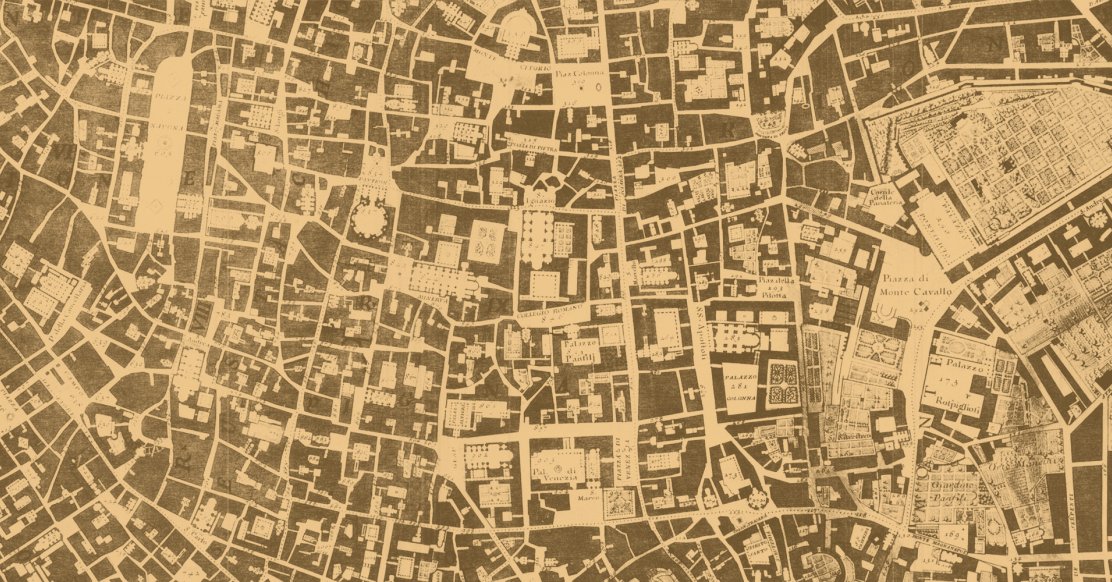
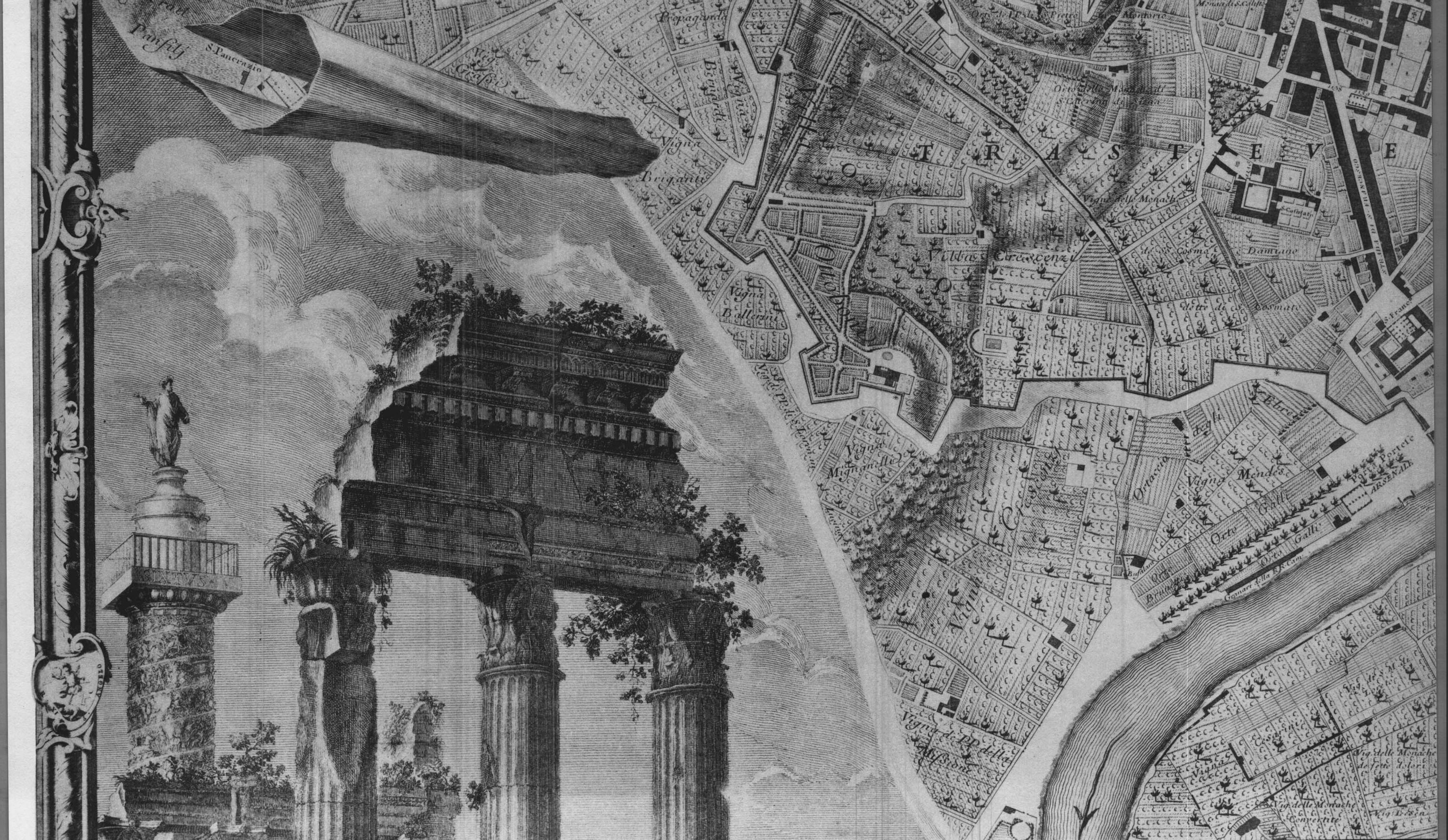
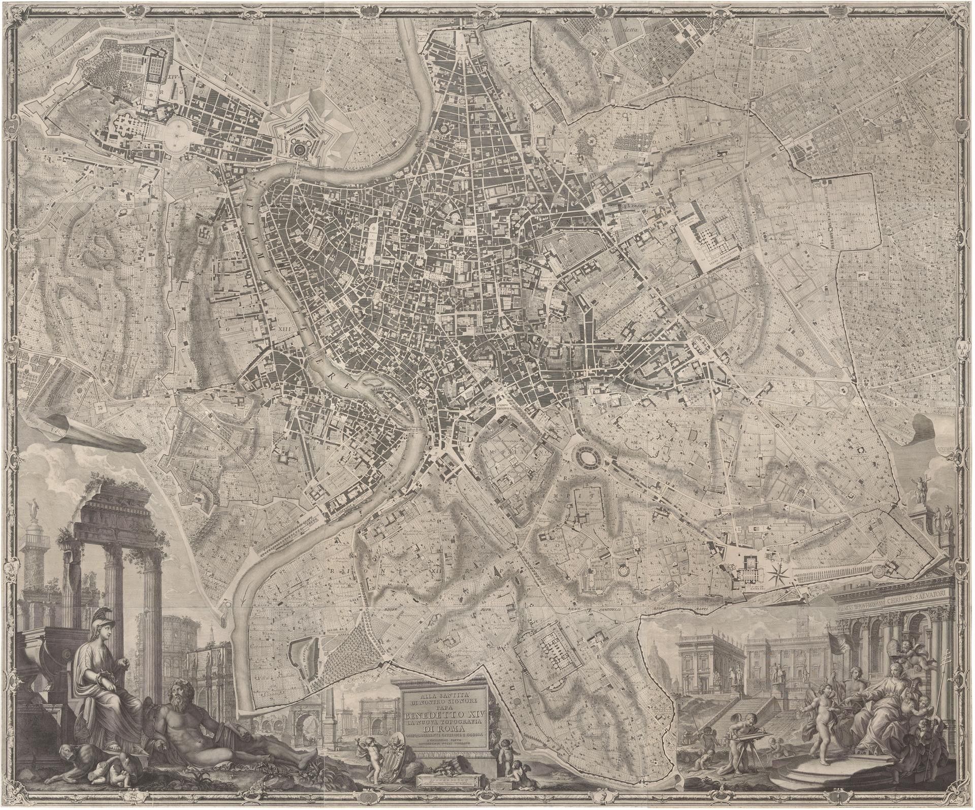
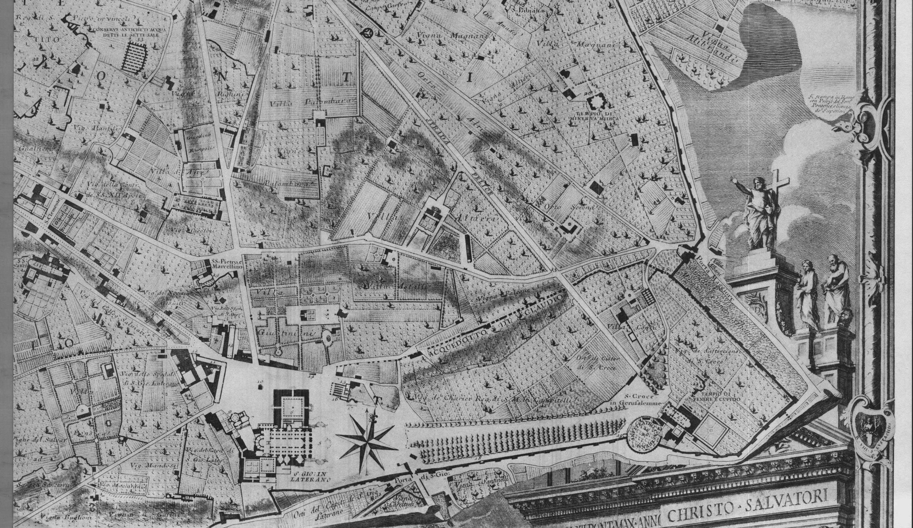
Giambattista Nolli's magnum opus, the map of Rome titled "La Pianta Grande di Roma," stands as an architectural treasure and a masterpiece of cartography. This map, created in the 18th century, offers a meticulously detailed view of the Eternal City during a period of architectural and urban transformation.
Nolli and his team of skilled surveyors and artists undertook an extensive survey, measuring and recording every street, square, and building in Rome. The result is a breathtakingly detailed representation of the city that provides a vivid glimpse into its architectural and urban landscape at that time.
Nolli's map of Rome marked a revolutionary departure from traditional cartography. While conventional maps focused primarily on streets and geographical features, Nolli's innovation lay in his holistic approach to city mapping.
He expanded the scope to encompass not only streets and buildings but also public spaces and open areas, thereby offering a comprehensive and interconnected view of the urban environment.
Moreover, Nolli introduced a groundbreaking technique of using negative space to depict interior spaces and courtyards within buildings. This artistic choice not only added depth to the map but also emphasized the symbiotic relationship between interior and exterior spaces within the city.
The Nolli map of Rome is replete with key features and elements that make it a unique and enduring treasure. Perhaps the most striking feature is Nolli's use of negative space to depict the interior courtyards of buildings.
Instead of solidly shading the building footprint, these spaces are left blank, creating a visual contrast that highlights the interconnectedness of interior and exterior spaces within the city.
Nolli Maps Today: Preservation and Accessibility
Preserving Nolli maps is not just a matter of conserving historical artifacts; it's an endeavor to safeguard a vital piece of our urban heritage. These maps offer invaluable insights into the architectural and urban landscapes of the past, allowing us to understand the evolution of cities and their design principles.
As the cities they represent continue to change, Nolli maps become essential reference points for preserving cultural memory and heritage. Moreover, they serve as valuable tools for contemporary architects, urban planners, and historians, offering a window into the architectural styles and city layouts of centuries gone by.
Nolli maps can be found in prestigious institutions, libraries, and museums around the world. Many of these institutions recognize the significance of these maps and have taken steps to ensure their preservation.
In particular, cities like Rome, where Giambattista Nolli's most famous map was created, often house physical copies of these maps in museums and archives. Museums with strong cartography collections, such as the Vatican Museums and the British Library, also house copies of Nolli maps for academic study and public viewing.
Nolli Maps in the Digital Age
In our digital age, the accessibility of Nolli maps has been greatly expanded. Many institutions have digitized their collections, making Nolli maps available to a global audience.
Online resources and platforms like digital archives, university libraries, and cultural heritage websites offer high-resolution digital versions of these maps, allowing researchers, historians, and enthusiasts to explore them from the comfort of their own computers.
Additionally, these digital versions often allow for interactive features, enabling users to zoom in, compare different time periods, and study specific details in depth.
Creating Your Own Nolli Map
Creating your own Nolli map can be a rewarding and educational experience. To get started, you'll need to select a city or area of interest. Begin by collecting accurate geographical data, including street layouts and landmarks.
Next, consider the scale of your map, as Nolli Maps are known for their intricate detail. Using this data, sketch the outlines of buildings and streets, paying attention to the architectural features and open spaces. To capture the essence of Nolli Maps, use negative space to depict interior courtyards within buildings.
But you don't need to slave away for hours to create your very own Nolli map depicting areas of importance to you. There’s no need to whip out Photoshop or pay a visit to your local historical society. Now, you can create your very own Nolli map right here, at MixPlaces!
Making Custom Nolli Maps with MixPlaces
At MixPlaces, we've redefined the art of creating Nolli maps, offering a powerful and intuitive platform for designers and cartographers.
Nolli maps, inspired by Giambattista Nolli's iconic 18th-century map of Rome, provide a unique view of urban landscapes by showcasing not just the usual street and building layouts, but also public spaces, gardens, and critical urban features.
With MixPlaces, crafting custom maps has never been more efficient and seamless. Our platform empowers users to overlay rich data layers onto detailed base maps, enabling a deeper understanding of urban patterns and design principles.
We emphasize customization, allowing users to incorporate both historical and contemporary data, illustrating urban connectivity and accessibility. MixPlaces facilitates the creation of Nolli maps that merge historical context with modern insights, enhancing our appreciation and comprehension of urban environments.
Nolli Maps vs. Modern Cartography
Nolli maps and modern cartography represent two distinct approaches to mapping cities. Nolli maps, created in the 18th century, are renowned for their artistic detail and holistic representation of urban environments.
They incorporate interior spaces, open courtyards, and streets, offering a unique perspective on the interconnectedness of urban life. In contrast, contemporary mapping techniques, often digital and GPS-based, prioritize geographic accuracy, real-time data, and navigation.
While modern maps excel at providing up-to-date information for navigation, they may lack the artistic and historical depth found in Nolli maps.
The advantages of Nolli maps in the modern age lie in their historical and cultural significance. They serve as valuable references for architects, urban planners, and historians, offering insights into architectural styles and urban development from centuries past.
Additionally, Nolli maps can inspire a deeper understanding of urban design principles by highlighting the relationship between interior and exterior spaces. However, Nolli maps do have limitations in the context of contemporary cartography. They may not provide real-time data, making them less suitable for practical navigation and location-based services.
The painstaking process of creating Nolli maps may be time-consuming and resource-intensive compared to modern mapping techniques, which can quickly generate detailed maps using satellite imagery and digital tools.
Nolli maps, with their innovative use of negative space and emphasis on the interconnectedness of urban spaces, can serve as a wellspring of inspiration for contemporary cartographers.
Modern cartographers can draw from Nolli's artistic techniques to infuse creativity and depth into their maps. They can explore ways to incorporate historical and cultural elements into their work, creating maps that not only provide geographical information but also tell compelling stories about the places they represent.
Understanding Nolli Maps: Frequently Asked Questions
Now that you’re equipped with historical and artistic contexts surrounding Nolli maps, let’s answer some common questions about this cartographic style.
What is a Nolli map?
A Nolli map is a unique form of city map created by Giambattista Nolli in the 18th century. Unlike traditional maps that focus solely on streets and geographical features, Nolli Maps take a holistic approach to city mapping.
They provide detailed representations of cities, incorporating not only streets and buildings but also public spaces, open courtyards, and gardens.
Nolli Maps are renowned for their innovative use of negative space, where interior spaces within buildings are left blank, creating a striking visual contrast that highlights the relationship between interior and exterior spaces.
These maps are considered works of art as well as valuable historical and cartographic documents.
How to Make a Nolli Map
Creating a Nolli map involves several key steps.
First, choose a city or area of interest and collect accurate geographical data, including street layouts and landmarks.
Then, decide on the scale and level of detail you want to achieve. Sketch the outlines of buildings, streets, squares, and public spaces, paying attention to architectural features.
To capture the essence of a Nolli map, use negative space to depict interior courtyards within buildings, creating a sense of depth and interconnectedness.
You can create a Nolli map using traditional drawing techniques, digital softwares, or you can make your life a whole lot easier by creating your Nolli map here at MixPlaces.
What does a Nolli map show?
A Nolli map shows much more than just the physical layout of a city. It provides a comprehensive view of urban life and design during the time it was created.
In addition to streets and buildings, Nolli maps depict open spaces, gardens, parks, and the relationships between interior and exterior spaces within buildings. They offer insights into architectural styles, the use of negative space, and the interconnectedness of public and private spaces.
Nolli maps are a window into the past, offering a snapshot of a city's architectural and urban landscape during a specific historical period.
Exploring the Historical and Practical Aspects of Nolli Maps
Nolli maps have both historical and practical significance.
Historically, they serve as valuable records of the architectural and urban development of cities in the 18th century. They are essential references for architects, urban planners, and historians studying architectural styles, building materials, and the evolution of city planning.
Practically, Nolli maps can inspire contemporary cartographers and urban designers to adopt a more holistic approach to mapping. They can also serve as tools for understanding how cities have evolved over time and for making informed decisions about urban development.
Overall, Nolli maps offer a rich blend of history, art, and cartography, making them a fascinating subject of study and exploration.
Mapping Out Some Final Thoughts
Nolli maps represent a pivotal moment in the world of cartography. Giambattista Nolli's innovative approach to city mapping, with his intricate depictions of streets, buildings, courtyards, and open spaces, transcends the traditional role of maps as navigational tools.
These maps offer a comprehensive view of urban life and design, emphasizing the interconnectedness of interior and exterior spaces within cities.
Their historical and cultural significance cannot be overstated, serving as invaluable resources for architects, urban planners, and historians seeking to understand the architectural and urban evolution of cities in the 18th century.
Following in Nolli’s Footsteps
Whether you're an architect, urban planner, historian, or simply a lover of maps, the Nolli map technique offers a captivating way to view and represent cities. By following the footsteps of Giambattista Nolli, you can gain a deeper appreciation for the art and science of cartography, as well as gain a unique perspective on the cities you encounter.
Be it through traditional drawing techniques or digital softwares, embarking on the journey of creating a Nolli-style map can be both educational and creatively rewarding.
We cannot overlook the enduring legacy of Giambattista Nolli and his remarkable cartographic work. His maps continue to inspire and inform contemporary cartographers, architects, and urban planners.
Nolli's innovative techniques, such as the use of negative space, offer valuable lessons in how we can represent and understand our ever-evolving cities.
As we reflect on the legacy of Nolli and his maps, we are reminded of the enduring power of cartography to shape our understanding of the world and the cities we inhabit.
In honoring Giambattista Nolli, we celebrate not only a cartographic genius but also a visionary whose work continues to enrich our knowledge of the past and our inspiration for the future.