Topographic Map vs Hillshade Map: What's The Difference?
In today's ever-evolving world, maps play a pivotal role in helping us understand and navigate our surroundings. They visually represent geographical data, showcasing terrains, landmarks, and features that define our environment.
Among these varied mapping techniques are topographic maps and hillshade maps, each uniquely portraying landscape details.
Topographic maps, with their detailed contour lines and symbols, offer a comprehensive representation of the Earth's surface. These maps assist in understanding not only elevation changes but also specific geographic features like rivers, forests, and human-made structures.
This makes them particularly useful for outdoor enthusiasts, hikers, and planners who need a more intuitive grasp of the terrain's ruggedness and accessibility. But what are the differences between them? And which one is better?

Topographic Maps, Hillshade Maps, and MixPlaces
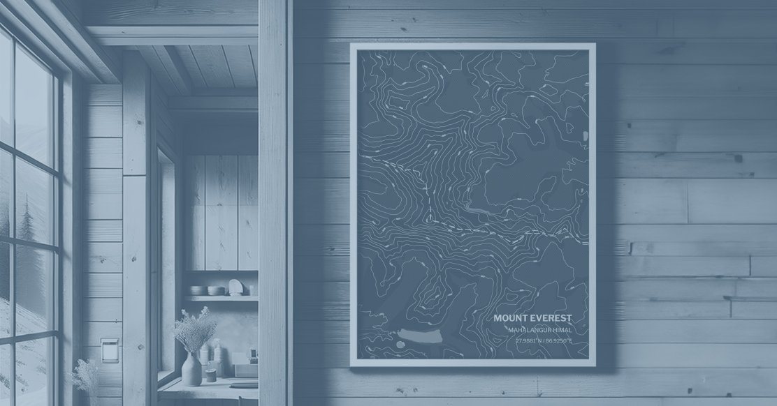
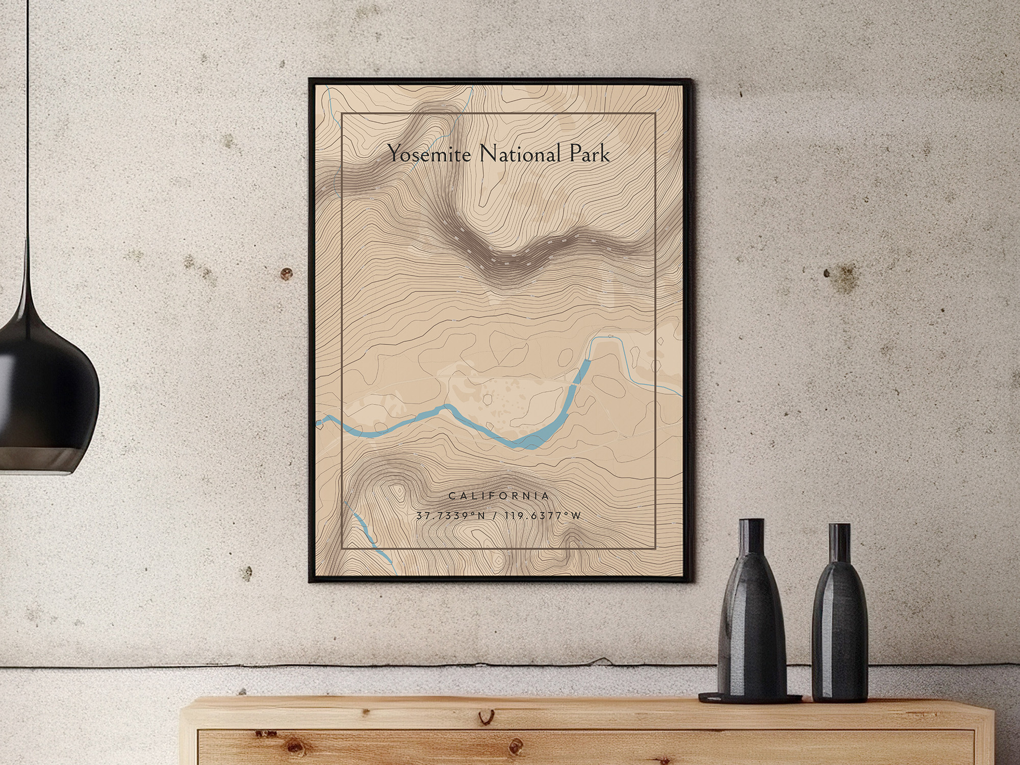
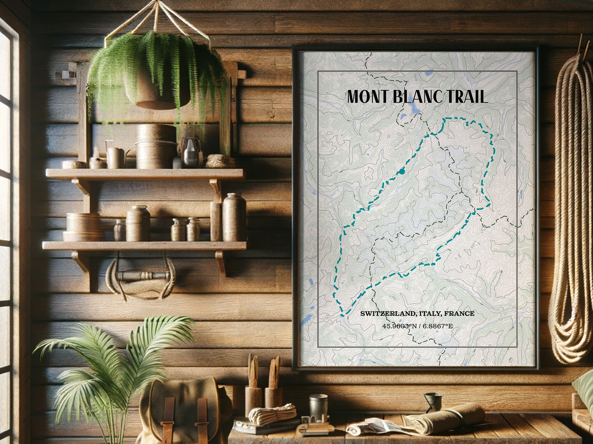
In today's dynamic world, where the appreciation for personalized experiences is on the rise, there's a unique destination that allows users to craft and personalize their own topographic and hillshade maps – welcome to MixPlaces!
Leveraging top-of-the-line GPS (Global Positioning System) and GIS (Geographic Information System) technology, we empower users to create accurate, high-quality maps for any place in the world.
MixPlaces is not just a mapping platform; it's a gateway for individuals, explorers, and planners to tailor their maps to specific preferences and needs.
Whether you're an outdoor enthusiast planning a hiking adventure, a geographer conducting in-depth research, or a traveler seeking a one-of-a-kind keepsake, MixPlaces provides the tools to make your mapping experience truly your own.
Why We’re the Best
With MixPlaces, you can delve into the intricate details of topographic maps, understanding the nuances of elevation changes, landmarks, and terrain features.
We go beyond traditional mapping by offering the added dimension of hillshade maps, where the interplay of light and shadow brings landscapes to life, revealing the beauty of slopes and landforms.
The secret to MixPlaces maps lies in our commitment to accuracy and quality. By harnessing advanced GPS and GIS technologies, we ensure that every map created is a precise representation of the chosen location.
This attention to detail makes MixPlaces an invaluable resource for a myriad of purposes, from academic and professional use to personal exploration and adventure planning.
Defining Topographic Maps
Topographic maps are comprehensive representations of Earth's surface, depicting terrain features such as hills, valleys, forests, and human-made structures. These maps portray elevation through contour lines, showcasing the three-dimensional landscape on a two-dimensional surface.
Key to understanding landscapes, they offer insights into physical geography and are crucial tools for geologists, hikers, and urban planners.
The history of topographic mapping dates back centuries, evolving from early hand-drawn maps to the modern, digitized versions we use today.
The United States Geological Survey (USGS) played a significant role, starting its mapping endeavors in the late 19th century. Throughout history, these maps have evolved in accuracy and detail, keeping pace with technological advancements.
Contour lines, symbols, and scale are fundamental elements of topographic maps. Contour lines represent elevation and relief, showing the shape and steepness of terrain. Symbols denote various features like roads, buildings, rivers, and vegetation, aiding in easy interpretation.
Additionally, the map scale indicates the relationship between distances on the map and actual distances on the ground, ensuring accurate navigation and measurement.
Understanding Hillshade Maps
Hillshade maps simulate lighting on terrain to portray landscapes in a 3D-like representation, using various shades of gray. Their emphasis on visual aesthetics employs light and shadow to accentuate land features and convey topographical information effectively.
These maps are invaluable for perceiving and comprehending the nuances of terrain, particularly in outdoor activities like hiking and navigation. Through the interplay of light and shadow, hillshade maps provide a nuanced understanding of slopes, elevation changes, and landforms.
Hillshade maps excel in providing a visually appealing depiction of terrain relief through simulated lighting effects. By mimicking natural lighting conditions and creating shadows on the landscape, hillshade maps facilitate a more intuitive understanding of the topography.
They are highly beneficial in recreational activities such as hiking, mountaineering, and outdoor exploration, where a quick grasp of the terrain's visual appearance is crucial for navigation.
By leveraging lighting effects, hillshade maps offer an intuitive way to interpret landscape features, aiding cartographers and hikers in evaluating and navigating terrains. They illuminate the complexity of topography, allowing for clearer visual assessments of geographic landscapes.
Main Differences
The main differences between topographic and hillshade maps lie in their primary purposes and distinct characteristics. Topographic maps focus on displaying detailed terrain, contour lines, and man-made features, aiding in navigation, land surveying, and environmental studies.
On the other hand, hillshade maps emphasize visual aesthetics by simulating light and shadow on terrain. Their primary goal is to offer a more visually appealing and intuitive representation of landscapes, facilitating a quick understanding of elevation and relief.
These maps are often used in artistic or illustrative contexts and complement topographic maps in GIS and mapping technologies.
| Aspect | Topographic Maps | Hillshade Maps |
|---|---|---|
| Primary Purpose | Detailed terrain depiction, navigation aid, land surveying, environmental studies | Emphasizes visual aesthetics, provides intuitive representation of landscapes |
| Focus | Detailed geographic features, contour lines, man-made structures | Visual representation of light and shadow on terrain for aesthetic appeal |
| Usage Context | GIS, mapping technologies, scientific research, geological studies, civil engineering | Artistic, illustrative contexts, outdoor activities, public presentations |
| Information Detail | Technical data, precise elevation measurements, contour lines | Emphasizes visual clarity over technical details |
| Suitability | Best for technical analysis, land management decisions | More suitable for general understanding, artistic or public presentations |
Hillshade maps focus on providing a more visually comprehensible representation of landscapes, emphasizing aesthetic appeal and ease of interpretation, making them more suitable for general or artistic purposes, outdoor activities, and public presentations where visual impact takes precedence over detailed technical information.
Data Representation
Elevation data is portrayed distinctively in topographic and hillshade maps. Topographic maps employ contour lines, offering precise elevation information and delineating changes in terrain.
In contrast, hillshade maps visualize elevation using simulated light and shadow, emphasizing relief and land features through shading techniques.
Interpreting relief and terrain on topographic maps involves analyzing contour lines, aiding in understanding the landscape's shape and elevation changes. These lines indicate slopes, valleys, ridges, and flat areas.
Conversely, hillshade maps focus on visual perception by displaying terrain through light and shadow, providing a more realistic representation of elevation changes and land features.
In topographic maps, contour lines intricately showcase the elevation changes of the terrain. These lines not only illustrate the heights of various geographic features but also help in gauging the steepness of slopes.
By closely examining the pattern, spacing, and arrangement of contour lines, users can infer the landscape's gradient, aiding in understanding how the landform transitions from high to low elevations.
Conversely, hillshade maps use varying shades of light and shadow to present a more perceptible view of the land's surface, offering a realistic and visually immersive representation that enhances the observer's spatial understanding of the landscape's topography.
Applications in Various Fields
Topographic maps find diverse applications across geography, environmental sciences, urban planning, and more. In geography, these maps aid in understanding landforms, guiding fieldwork, and conducting spatial analysis.
They're crucial for land management, providing insights into terrain for conservation and resource planning. Additionally, in urban planning, topographic maps assist in infrastructure development, zoning, and identifying suitable locations for construction.
Here's a list outlining the applications of topographic and hillshade maps across different fields:
Topographic Maps:
- Geography: Aid in understanding landforms, guiding fieldwork, and conducting spatial analysis.
- Land Management: Provide insights into terrain for conservation efforts and resource planning.
- Urban Planning: Assist in infrastructure development, zoning, and identifying suitable locations for construction.
Hillshade Maps:
- Outdoor Activities: Useful for hiking, camping, trekking, providing a visually appealing representation of terrains.
- Geographic Information Systems (GIS): Contribute to landscape visualization, aiding in land-use planning and environmental modeling.
- Realistic Terrain Representation: Hillshade maps offer a realistic portrayal of terrain, enhancing interpretability for non-experts and professionals in various fields.
The advantage of hillshade maps lies in their realistic portrayal of terrain, enhancing interpretability for non-experts and professionals alike. Both map types offer unique perspectives, catering to various applications in different fields.
Combining Both Maps
Integrating topographic and hillshade maps offers a comprehensive understanding of terrains. Topographic maps provide precise elevation data, while hillshade maps visually represent terrain shadows and relief.
The fusion enhances the visual appeal and comprehension of geographic features, aiding in interpreting landscapes with depth and detail.
In GIS applications, combining both maps enables a holistic view of the landscape. Utilizing the elevation data from topographic maps and the shading effects of hillshade maps assists in producing highly detailed, visually rich cartographic outputs.
By integrating these map types, GIS analysts and cartographers can create enhanced representations that blend accurate elevation information with realistic visualizations of terrain.
The choice between topographic and hillshade maps often hinges on the purpose and intended use. Topographic maps are favored for their precision and detailed information, making them indispensable for professionals requiring exact elevation data.
In contrast, hillshade maps are preferred when a more visual, realistic, and aesthetically pleasing representation of terrain is desired, especially for artists, illustrators, and outdoor enthusiasts seeking a more intuitive understanding of landscapes.
Employing techniques such as layering both map types in GIS software allows for a more comprehensive analysis.
The amalgamation of topographic maps' quantitative elevation data with the visual context provided by hillshade maps enhances decision-making in land management, environmental studies, and infrastructure planning.
This integration aids in creating informative, visually appealing maps that convey comprehensive geographic information.
Technological Advancements
To wrap things up, understanding the nuances between topographic and hillshade maps is crucial. Topographic maps offer comprehensive elevation information, while hillshade maps focus on visualizing terrain with artistic depth.
When choosing between the two, consider the purpose: topographic maps for detailed geographic analysis and hillshade maps for a more visually appealing representation.
Key takeaways include recognizing the distinct purposes and data representations each map type offers. Topographic maps excel in conveying detailed terrain features, while hillshade maps provide a more visual and realistic depiction of landscapes.
Choosing the right map depends on your specific needs, whether for scientific analysis, urban planning, or aesthetic appreciation.
Selecting between topographic and hillshade maps relies on your intended use and preference for information presentation. Both map types serve unique purposes, offering valuable insights into terrain and landscapes.
Ultimately, understanding their differences empowers users to make informed choices, ensuring the most suitable map selection for diverse mapping needs. Mechnological advancements have revolutionized map creation, introducing sophisticated tools and software that facilitate intricate detailing and precision.
MixPlaces, with its innovative mapping technology, has redefined the way we visualize and personalize maps, offering a diverse range of features for users to craft unique and detailed representations.
The future of mapping is poised for exciting developments, driven by the continual evolution of technology. Advancements in AI, machine learning, and augmented reality are set to transform mapping experiences, enhancing accuracy, interactivity, and accessibility.
This evolution will likely offer new dimensions for map users, empowering them with immersive and intuitive tools for exploration and navigation.
As we move forward, the integration of emerging technologies will undoubtedly shape the landscape of mapping.
From real-time updates to enhanced data visualization techniques, the future holds promise for more dynamic, interactive, and user-friendly mapping experiences, providing users with an enriched understanding of our surroundings and the world at large.
To Wrap Things Up
To wrap things up, understanding the nuances between topographic and hillshade maps is crucial. Topographic maps offer comprehensive elevation information, while hillshade maps focus on visualizing terrain with artistic depth.
When choosing between the two, consider the purpose: topographic maps for detailed geographic analysis and hillshade maps for a more visually appealing representation.
Key takeaways include recognizing the distinct purposes and data representations each map type offers. Topographic maps excel in conveying detailed terrain features, while hillshade maps provide a more visual and realistic depiction of landscapes.
Choosing the right map depends on your specific needs, whether for scientific analysis, urban planning, or aesthetic appreciation.
Both topographic and hillshade maps serve distinct yet complementary purposes in conveying geographic information. While topographic maps excel in precise data representation, hillshade maps add an artistic dimension to terrain visualization, enriching our perception and appreciation of the natural world.
Understanding the distinctive features and applications of each map type empowers users to select the most suitable map based on their specific needs and preferences.