Geographic Coordinate System: What is Latitude & Longitude?
Whether in geography class, in movies, or from your outdoor adventurer friends, you may have heard the terms latitude and longitude tossed around.
We all know these terms are important for navigation, but what exactly is latitude and longitude? And how are these tools useful in the modern day, from GPS and social media geotagging to personalized coordinates posters?
In short, latitude and longitude constitute the Earth's geographic coordinate system, enabling the precise identification of any location on the Earth's surface. This system is based on a network of imaginary lines that circle the globe both vertically and horizontally.
Latitude lines run parallel to the Equator and measure the distance north or south from it, expressed in degrees from 0° at the Equator to 90° at the poles. Longitude lines, also known as meridians, run from the North Pole to the South Pole, measuring the distance east or west of the Prime Meridian, which is designated at 0°, extending up to 180° in both directions.
Understanding Coordinates
Imagine the Earth encased in a transparent sphere, with the Equator and the Prime Meridian serving as the baseline references for latitude and longitude, respectively. The Equator splits up the planet’s northern and southern hemispheres, and the Prime Meridian splits up the Earth’s eastern and western hemispheres.
If your brain is mathematical, you’re already seeing a plane with four quadrants in your brain. And if you really love math, you already know that's called a Cartesian Plane.
With that understanding, latitude and longitude lines are what divides this plane into even smaller sections, allowing for the more accurate representation of specific locations all around the world.
Apart from being split into four quadrants, the Earth is segmented into a grid that allows for precise location tracking by using latitude and longitude lines.
Each degree of latitude and longitude is further divided into minutes (') and seconds ("), offering a level of accuracy necessary for detailed mapping and navigation.
Latitude vs. Longitude: What’s the Difference?
The main key difference between latitude and longitude lines is, of course, that latitude lines run east to west, while longitude lines run north to south. But that’s not where their differences end.
Latitude and longitude lines serve different purposes and possess distinct characteristics. Latitude lines are equidistant from each other, each approximately 69 miles (111 kilometers) apart.
In contrast, longitude lines converge at the poles and are farthest apart at the Equator. The equidistant nature of latitude lines aids in the simple calculation of distance north or south of the Equator.
Conversely, the calculation of distance based on longitude requires accounting for the convergence of lines towards the poles and varies depending on the latitude.

How to Read Coordinates on a Map
Reading coordinates involves identifying the intersection point of latitude and longitude lines on a map. Coordinates are typically presented in degrees, minutes, and seconds (DMS) or in decimal degrees (DD).
For example, the coordinates for the Eiffel Tower in Paris, France, might be expressed as 48° 51' 29" N, 2° 17' 40" E in DMS format or 48.8581° N, 2.2945° E in DD format.
The 'N' or 'E' indicates the direction from the Equator or Prime Meridian, respectively, essential for pinpointing the exact location on a global scale.
If your brain processes words better than numbers, these ordered pairs just mean that the Eiffel Tower is 48 degrees, 51 minutes, and 29 seconds north of the Equator and 2 degrees, 17 minutes, and 40 seconds east of the Prime Meridian.
Using these two points of reference, you can find the coordinates to any place in the entire world!
Latitude & Longitude For Navigation
The most direct application of latitude and longitude is in navigation, whether at sea, in the air, or on land.
Modern GPS technology has made it possible to use these coordinates to navigate with a precision that was unimaginable just a few decades ago.
For instance, sailors and pilots use these coordinates to chart courses across oceans and skies, while emergency services use them to locate individuals in need of assistance rapidly.
The ability to pinpoint locations accurately is not just a matter of convenience but often one of survival, efficiency, and critical logistics.
Latitude and Longitude Lines: Other Real World Applications
You already know that latitude and longitude lines are crucial in facilitating navigation and mapping, but they do much more than just that.
Latitude and longitude lines also play a crucial role in defining time zones, with each hour time difference corresponding to 15° of longitude.
Furthermore, these coordinates are integral to the study of Earth's climate, as latitude significantly influences climate zones.
By understanding the significance and application of these lines, we gain deeper insights into the interconnectedness of geography, time, navigation, and environmental science.
Even fun, light activities such as snapping selfies and uploading them on social media employ latitude and longitude lines.
When you tag photos of your exquisite vacation photos as taken in Bali, for example, your social media apps are deriving GPS data based on the latitude/longitude coordinate system to pinpoint your location.
But there’s an even more fun application for coordinates— one that involves zero math and a whole lot of your favorite memories!

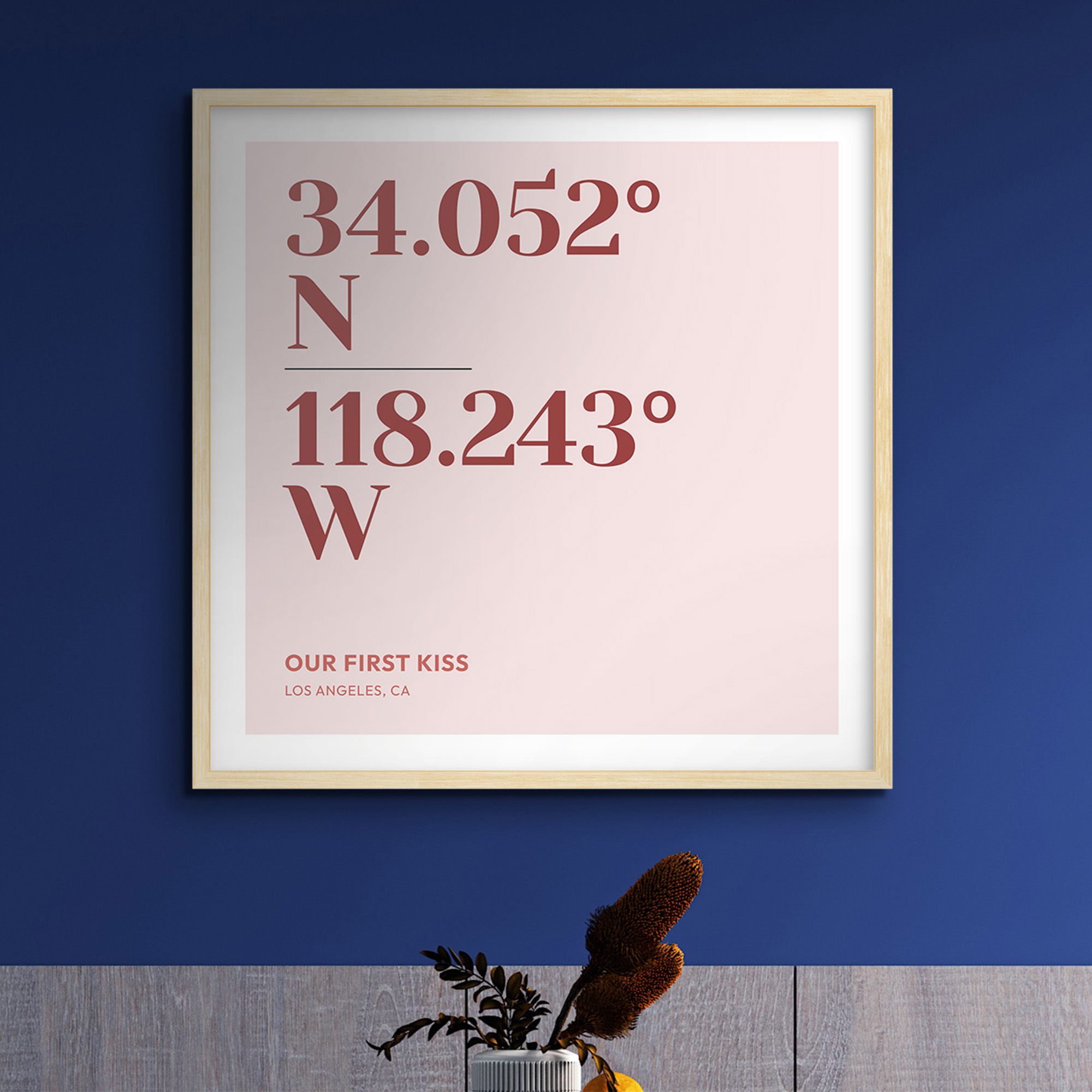
Latitude, Longitude, & The Coordinates to Your Happy Place
One of the most creative applications for latitude and longitude is creating personalized coordinates art.
This art form encompasses (pun most certainly intended) taking a special, meaningful place to you and creating high-quality, one-of-a-kind art inspired by your own memories and crafted specially to fit your exact aesthetics.
But how is this done? Well, all you need to do is head on over to our coordinates art builder, plug in the name of a location you want to cherish, and then customize your heart away with colors, layouts, texts, and more.
You can even choose whether you want your coordinates displayed in degrees, minutes, and seconds or in decimal degrees.
The locations can be as specific or as broad as you’d prefer. You can choose to find the coordinates for a home, a neighborhood, an entire city, or even a whole country! The choice is completely up to you.
Be it the ballroom you celebrated your wedding, the place your child was born, your first home, or the greatest trip of your life, you can commemorate all your favorite moments with latitude and longitude lines.
And the best part is, you can completely customize your coordinates poster in any way you want, from choosing the style of your art to its materials, size, and orientation. All it takes is a couple clicks and voila! You’ve got a customized, unique piece to liven up your home or office.
P.S: These also make incredible gifts.

Latitude and Longitude in Science and Research
It should come as no surprise that apart from navigation and beautiful wall art, latitude and longitude are also essential for science and research. From astronomy to environmental research, scientists in several fields of research employ these coordinates to discover more about our planet, our solar system, and even our galaxy.
The Role of Coordinates in Astronomy and Earth Sciences
In astronomy, coordinates are essential for tracking celestial bodies across the sky, while in earth sciences, they are crucial for studying geographical phenomena.
Latitude and longitude allow scientists to pinpoint specific locations for observation and data collection, enabling research into climate change, geological activity, and more.
This precise positioning is vital for understanding the Earth's processes and how they impact our environment and society.
Geographic Location Studies and Environmental Research
The study of geography and the environment relies on accurate geographic coordinates to monitor changes over time.
Researchers use these data to track the movement of wildlife, the spread of invasive species, and the impacts of climate change across different regions.
By analyzing geographic data, scientists can make predictions about future changes and develop strategies for conservation and sustainability.
Data Collection and Analysis Using Geo Coordinates
Geographic coordinates are indispensable for collecting and analyzing data in a myriad of fields. They enable the aggregation of information from diverse sources, providing a geographic context that enhances our understanding of social, economic, and environmental issues.
Through the use of GIS and other mapping tools, researchers can visualize complex data sets, uncover patterns, and derive insights that inform policy-making, business decisions, and scientific discoveries.
Latitude & Longitude: X or Y?
One common question people have about latitude and longitude lines is whether latitude represents the X or Y axis on a map.
In the context of the Earth's coordinate system, latitude corresponds to the Y-axis, indicating north-south positioning, while longitude corresponds to the X-axis, indicating east-west positioning.
It’s understandable to be a bit confused here, as latitude runs east to west, and is therefore commonly confused for representing the X axis, while the opposite is true for longitude.
Think of it this way: while latitude lines do run east to west, a set of latitude lines run east to west above and below the Equator, meaning that there are multiple latitude lines running east to west up and down the globe.
That's why they’re on the Y axis, because despite the lines itself running left to right, they're placed up and down the globe. Latitude lines determine how far north or south a point lies from the Equator.
Of course, the opposite is true for longitude. While these lines run north to south, multiple longitude lines run north to south all around the globe, placing them at different cardinal directions. These lines determine how far east or west a point lies from the Prime Meridian.
Final Thoughts
The systems of latitude and longitude are foundational to our understanding and navigation of the world. From ancient mariners to modern GPS technology, these coordinates have guided explorers, facilitated commerce, and enabled scientific discovery.
While our navigation may be greatly simplified due to modern advancements in GPS and GIS data, latitude and longitude lines can still be incredibly useful in new and creative ways. From creating personalized souvenirs from your favorite trips to commemorating the moments that make life great, you can use latitude and longitude lines to create customized, one-of-a-kind art that reflects the greatest story there is— yours!